


(Simon & Garfunkel, “The Only Living Boy in New York”, 1970)
FPI Highlights Strategic Partnership with The Weather Company™
with 6 Key Success Stories
(September 2025)
Paul Simon once mused, “half of the time we’re gone, but we don’t know where”. However, FPI clients should never share that concern — FPI knows exactly where they’re headed and are now better equipped than ever to anticipate how weather will affect their journeys.
Earlier this year, FPI entered into a strategic partnership with The Weather Company™, a globally recognized leader in aviation meteorology known for delivering highly accurate long-range forecasts tailored to airports and flight operations around the world.
Leveraging our in-house engineering expertise, FPI accesses data through The Weather Company’s™ Forecast on Demand (FOD) product, which provides hourly-updated forecasts extending up to 15 days. These forecasts are generated using a highly accurate, blended-model approach, specifically tailored to aviation-relevant parameters such as wind speed, visibility, ceiling, and precipitation type — enabling more informed and proactive operational decision-making.

This data complements our U.S.-based GFS model output, which updates four times daily and delivers forecast guidance out to 16 days, offering an additional layer of global perspective and temporal coverage for long-range planning.
One unique characteristic of the Forecast on Demand (FOD) product is its ability to more accurately depict atmospheric conditions in the lower levels of the atmosphere compared to some lower-resolution models. This enhanced vertical resolution is especially critical for determining accurate surface temperatures and dew points, which directly influence the probability of fog or freezing fog, as well as ceiling and visibility restrictions, all of which are vital to aviation forecasting and operational planning.
It is also essential to analyze the three-dimensional structure of the atmosphere, as this is critical for accurately determining temperature, dew point, wind velocity, and wind direction at various altitudes — particularly several thousand feet above an airport. For instance, identifying the presence of a temperature inversion or assessing the temperature–dew point spread just above the surface can reveal important insights into potential fog formation, cloud bases, and atmospheric stability.
These atmospheric conditions can often be forecast several days in advance by analyzing Skew-T log-P diagrams generated from numerical weather prediction models such as the ECMWF and GFS. Generally, the ECMWF model tends to more accurately represent the vertical structure of the atmosphere, particularly in the lower levels. This allows for improved forecasting of critical parameters—such as temperature inversions, moisture profiles, and wind shear — that directly impact flight planning, aircraft performance, and aviation safety.
Are weather models ever 100% accurate? Absolutely not. However, with access to model output from The Weather Company™, the U.S.-based Global Forecast System (GFS), and the European Centre for Medium-Range Weather Forecasts (ECMWF) suite of models, we have strong confidence in our ability to anticipate weather conditions many days in advance. By comparing and blending data from these high-performing models, we gain valuable insight and increase forecast reliability.
FPI’s strategic partnership with The Weather Company™ has not only positioned FPI with the ability to make swifter than usual critical recommendations for FPI clients, but the partnership also sets client operations teams up for success no matter what weather challenges lie ahead in the route.
“We strongly believe that the relationship with The Weather Company™ sets us apart from our competitors…” states Brad Asselin, FPI’s Director of Weather and Flight Planning Services, “offering a level of precision and foresight that’s critical for safe and efficient flight operations.”
– – –
Six Key Examples of Success
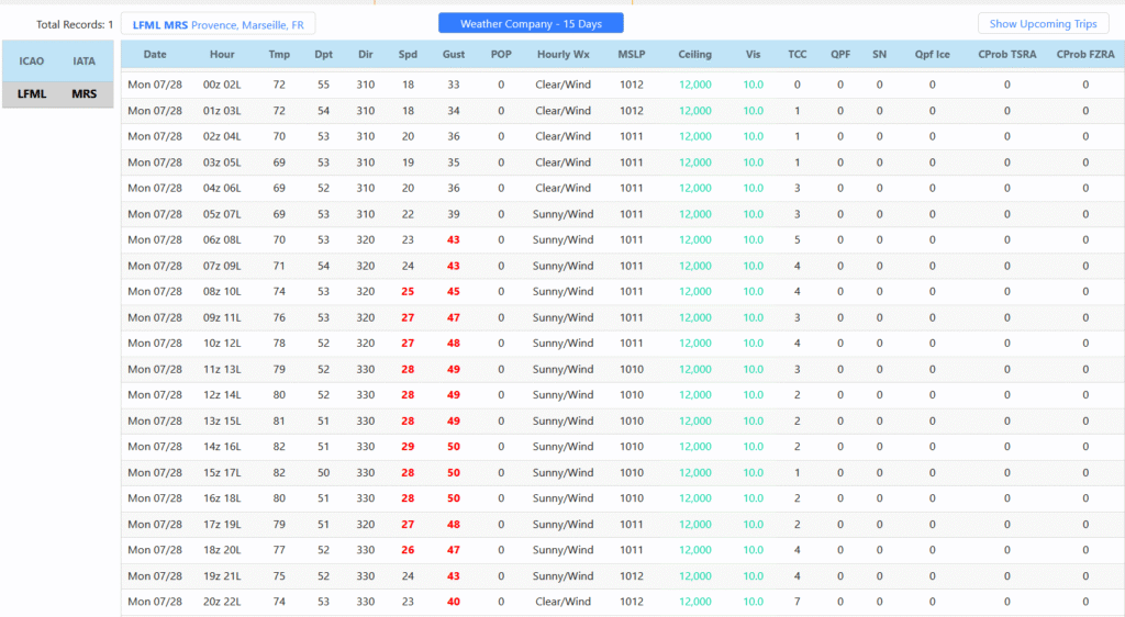
Example #1 — Approximately 48 to 60 hours in advance, we successfully alerted our client to the potential for strong, gusty winds at LFML (Marseille Provence Airport), with gusts expected to exceed 50 knots. This event was driven by a deep low-pressure system positioned to the east of the region, which, combined with a tight pressure gradient, triggered a significant Mistral wind event. The Mistral is a highly localized and often difficult-to-predict phenomenon, requiring careful analysis of both synoptic-scale dynamics and mesoscale features to forecast accurately.
The Weather Company’s surface text product proved invaluable in supporting our forecast decision-making, offering critical detail on pressure trends and surface wind behavior. This high-resolution, timely guidance enabled our client to proactively reposition to Nice, France, where wind conditions were significantly calmer, effectively avoiding potential operational disruptions at Marseille. This outcome underscores the importance of integrating precise surface-level data into aviation forecasting for optimal decision support.
– – – – – – – –
Example #2 — Earlier this summer, Paris, France experienced severe weather as a squall line, accompanied by heavy thunderstorms, hail, and wind gusts between 55 and 60 knots, moved into the area from the west. The event resulted in significant power outages and widespread disruption across the region.
We provided our client with 24 to 30 hours of advance notice regarding the potential for damaging winds and convective activity. Based on this early guidance, the client secured hangar space for their aircraft, effectively avoiding potential storm-related damage. As a result, they were able to complete their next day’s mission without interruption, highlighting the operational value of proactive, accurate weather intelligence.
– – – – – – – –
Example #3 — Another example of successful convective weather forecasting occurred at Chicago O’Hare International Airport (ORD). On Tuesday, July 15th at approximately 15Z, The Weather Company’s surface text product issued guidance for the following day, highlighting the potential for strong thunderstorms in the area.
While the observed METARs indicated that the storm timing was off by a few hours, the forecast accurately captured the intensity of the convection. The storms were severe enough to trigger a ground stop at O’Hare, validating the forecast’s operational significance. This case underscores the importance of anticipating high-impact weather events, even when precise timing may vary, and demonstrates the value of early guidance in mitigating disruption and supporting aviation decision-making.

– – – – – – – –
Example #4 — Another recent example of accurately forecasted very strong winds occurred at Marseille, France. The text weather product, issued at 18Z on Friday July 25, was valid for the Monday, July 28 time period. Notably, the forecast closely verified with the observed METARs from that day, demonstrating strong alignment in both wind speed and timing.
What makes this case unique is the unusual synoptic pattern for late July, featuring a strong low-pressure area to the east of Marseille coupled with a well-defined upper-level low over Northern Italy. This rare configuration contributed to the development of intense surface winds in a season when such events are typically uncommon.
– – – – – – – –
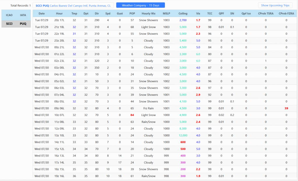
Example #5 — In the Southern Hemisphere, Punta Arenas, Chile (SCCI) reported light snow for several hours, which was successfully captured by The Weather Company’s forecast. The official terminal forecast, issued around 1620Z, however, did not indicate the possibility of snow, instead calling for light drizzle with visibilities no less than 4,000 meters.
For this example, forecast data was downloaded at 19Z on July 29th, representing a 24-hour forecast. Overall, the forecast was very accurate, especially regarding the temperature and dew point, with only minor discrepancies in the timing of precipitation onset and duration. Importantly, the forecast correctly identified the weather type, capturing the presence of light snow.
Additionally, the forecast accurately anticipated an increase in wind velocity after 15Z from an easterly direction, demonstrating strong performance in predicting wind changes.
– – – – – – – –
Example #6 — Tropical storm Krosa with a max intensity of 60 knots gusting to 75 knots came within 100 miles of Tokyo’s Narita airport at 18z on August 1st (to the East) before quickly moving off to the Northeast over the Western Pacific Ocean. This was a very difficult storm to forecast as the reliable computer models had differing solutions, even 48 hours, with the Joint Typhoon Forecast office mentioning this was a low-confidence forecast. WX company forecast data was downloaded at 18Z on July 30th, strategically chosen to align with the expected period of greatest impact from Tropical Storm Krosa on the Tokyo area. This allowed for targeted assessment of forecast accuracy during the storm’s closest approach.
As is common with tropical cyclone guidance, the model slightly underestimated the wind intensity by a few knots. This is a known and well-documented tendency, as global models often struggle to resolve maximum surface wind speeds within the compact core of tropical systems. Despite this limitation, the overall structure, track, and timing of the storm were well captured, lending credibility to the forecast guidance and providing valuable lead time for decision-makers.

– – – – – – – –
“Faster weather insights, sharper recommendations, and critical aviation technology alliances are key reasons that our clients will experience stronger operations thanks to FPI’s strategic partnership with The Weather Company™,” states Matt Pahl, FPI’s President and COO.
“When we’re better equipped, our clients are better equipped to succeed no matter what weather challenges arise before and during the route.”
So Mr. Paul Simon, don’t fret. Along with the rest of FPI’s clients, we’ve got you covered, as FPI takes very seriously the “news we get from the weather report.”
Therefore, “Tom, get your plane right on time, I know your part’ll go fine.”
Lyrics taken from “The Only Living Boy In New York”, by Simon & Garfunkel (1970).
— — —
To learn more about FPI, FPC, or regarding the Compliance, Operations, Regulatory, and other Special Services Network (SSN) teams, please contact our Operations staff here at Flight Pro International.
Our success is your success! Partner with us today.